Marine GPS technology has gotten complicated with all the features and integration options flying around. As someone who’s tested navigation equipment extensively on the water, I learned everything there is to know about choosing the right system for your boat. Today, I will share it all with you.
Choosing the Right Marine GPS
Navigation technology has transformed recreational and commercial boating, putting capabilities that once required extensive training and expensive equipment into accessible packages. Whether you’re cruising coastal waters, crossing oceans, or fishing your favorite spots, the right GPS unit can enhance safety, efficiency, and enjoyment on the water.
Chartplotter vs. Handheld GPS
Marine GPS units fall into two broad categories, each suited to different applications.
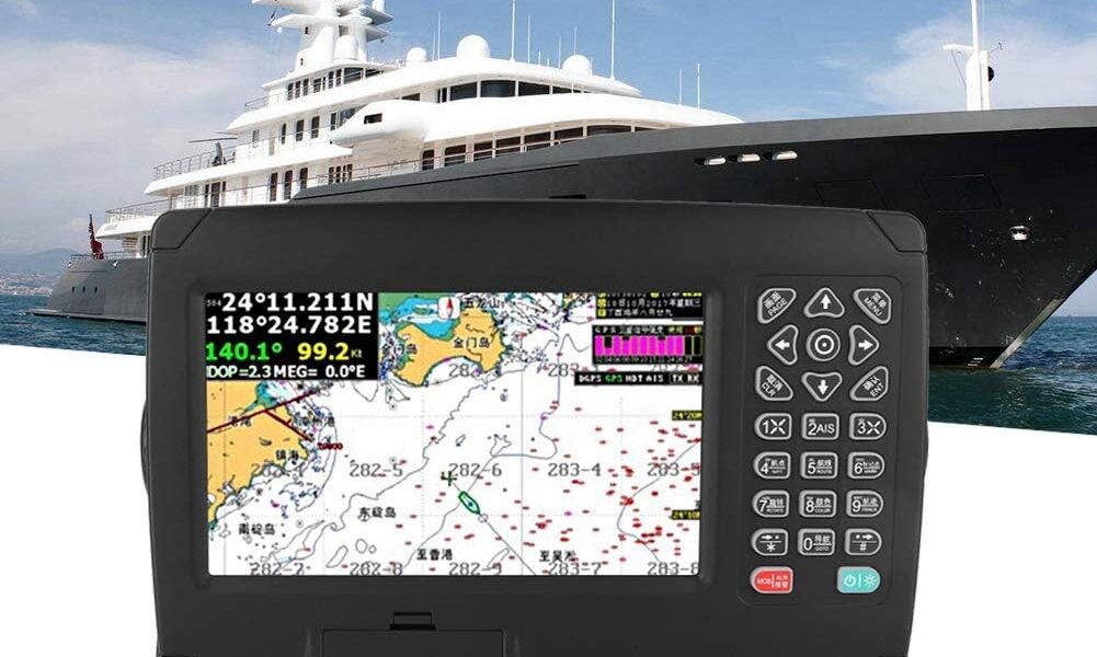
Chartplotters are fixed-mount units with larger displays that show your position on electronic charts. They integrate with other boat systems—radar, sonar, autopilot—creating comprehensive navigation stations. Modern chartplotters feature touchscreens, networking capability, and displays readable in direct sunlight.
Probably should have led with this section, honestly. Leading chartplotter manufacturers include Garmin, Raymarine, Simrad, Lowrance, and Furuno. Prices range from under $500 for basic units to over $5,000 for large-screen models with advanced features.
Handheld GPS units offer portability and redundancy. They’re ideal as backup navigation, for dinghy use, or for boats without space for fixed installation. Modern handhelds are waterproof, float, and include basic chartplotting capability.
Key Features to Consider
Display Size and Quality
Screen size directly affects usability. Larger displays show more chart area and are easier to read at a glance. Quality matters too—high-resolution screens with good sunlight visibility make a significant difference in practical use.
That’s what makes display selection so important. Multi-function displays that split between chart and other inputs (radar, sonar) benefit from generous screen real estate. For helm station installations, consider how the display integrates with your sightlines and other instruments.
Chart Coverage and Updates
The GPS unit is only as good as its charts. Major manufacturers offer cartography covering most cruising areas, but coverage quality varies by region. Before purchasing, verify that detailed charts are available for your primary cruising grounds.
Chart update policies differ by manufacturer. Some include lifetime updates; others charge annual subscription fees. Factor ongoing costs into your purchase decision.
Integration Capabilities
Modern chartplotters connect with other marine electronics via NMEA 2000 or Ethernet networks. This enables features like:
- Radar overlay on charts
- AIS target display
- Autopilot control
- Engine data monitoring
- Weather data integration
If you plan to expand your electronics over time, choose a chartplotter that supports robust networking.
Fishfinder Integration
Many chartplotters include built-in sonar or accept external transducers. For anglers, this integration puts fish location and bottom structure on the same screen as navigation. High-end units offer CHIRP sonar, down imaging, and side imaging capabilities.
Smartphone Apps as Supplements
Navigation apps like Navionics, Garmin BlueChart, and Aqua Map have made chart plotting accessible on phones and tablets. These apps offer surprising capability at low cost, making them attractive for casual boaters or as supplements to dedicated hardware.
However, smartphone limitations—battery life, screen visibility in sunlight, durability in marine environments—make them unsuitable as primary navigation for serious use. Consider apps as backup or planning tools rather than replacements for purpose-built marine electronics.
Installation Considerations
Proper installation affects performance. GPS antennas need clear sky views—obstructions degrade accuracy. Chartplotters should be positioned for visibility from the helm while protected from direct water spray.
Wiring should include adequate gauge for cable runs, with proper marine connectors and moisture protection. Professional installation is worthwhile for integrated systems with multiple components.
Recommendations by Use Case
Coastal cruisers benefit from mid-sized chartplotters (7-9 inches) with good chart coverage and basic radar integration capability. Budget $1,000-2,000 for a quality unit.
Offshore sailors need larger displays, robust networking, and integration with radar, AIS, and autopilot. Expect to invest $3,000 or more in navigation electronics.
Anglers should prioritize fishfinder integration and mapping features that show bottom contours and fishing spots. Combination units that handle both navigation and sonar offer good value.
Small boat operators may find handheld GPS units or smartphone apps adequate for their needs, supplemented by traditional navigation skills and local knowledge.
Whatever your boating style, modern GPS technology offers navigation capability that previous generations could only dream of. The challenge is selecting equipment matched to your needs and budget—and then learning to use it effectively.

Stay in the loop
Get the latest maritimematterstoday updates delivered to your inbox.